
BMRDA notifies new mobility road grid for Bengaluru Metropolitan Region
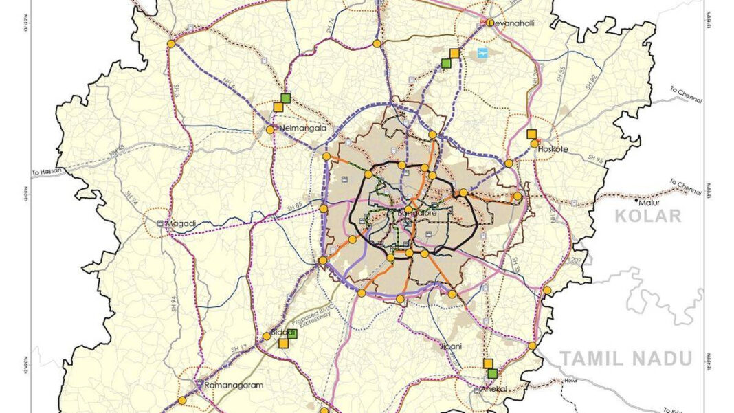
The Karnataka government has notified a new mobility road grid for the Bengaluru Metropolitan Region (BMR), laying out a blueprint to widen and connect hundreds of existing roads beyond the Greater Bengaluru Authority (GBA) area. The move aims to prevent the kind of congestion and infrastructure stress seen within the city from recurring in fast-urbanising outskirts.
Comprehensive grid to steer planned expansion
The notification, issued under the Revised Bengaluru Structure Plan-2031 by the Bengaluru Metropolitan Region Development Authority (BMRDA), focuses primarily on brownfield upgrades—widening small village roads and key regional connectors to accommodate rising traffic volumes and support planned growth.
“The new notification covers hundreds of roads, including existing zilla panchayat, PWD, and State Highway roads that have been proposed for widening. Roads that were previously as narrow as 10 metres have been notified for widths of 30 metres, 45 metres and, in some cases, up to 90 metres. These roads have been notified as Comprehensive Development Plan roads in a grid pattern to support planned urban expansion,” Greater Bengaluru Development Minister Krishna Byre Gowda said on Tuesday.
The initiative follows the recent expansion of the Bangalore Water Supply and Sewerage Board’s (BWSSB) service footprint to cover the entire Bengaluru Urban district, indicating a coordinated approach to infrastructure planning across water, mobility, and land use in the metropolitan region.
Data-led network planning
Rajendra Cholan, Metropolitan Commissioner of the BMRDA, said this is the first time a dedicated mobility grid exercise has been undertaken for the region, informed by a drone survey to identify missing links and gaps in the existing road network.
“Most of these are brownfield roads being widened. Village roads connecting to district roads, roads connecting to the Peripheral Ring Road, Satellite Township Ring Road and other such major corridors will be widened to 30 metres, even up to 45 metres,” he said.
He added that a key gap in east–south connectivity—between Anekal and Hoskote—will now be addressed with the development of a roughly 40-km road stretch. Other crucial corridors such as Chapparakallu Road and IVC Road, which function as important linkage routes, are also set for development under the plan.
Key features of the mobility grid
Designed as an integrated network, the mobility grid encompasses more than just road-widening:
- Designation of Comprehensive Development Plan (CDP) roads arranged in a grid to guide urban expansion
- Widening of existing zilla panchayat, PWD and State Highway roads to standardized widths—30m, 45m, and up to 90m in some locations
- Improved connectivity to major arterial corridors, including the Peripheral Ring Road (PRR) and Satellite Township Ring Road (STRR)
- Development of integrated freight hubs and intermodal transport hubs at major towns surrounding Bengaluru
- Provisions for proposed monorail, metro, and bus rapid transit (BRT) corridors
Phased rollout over five to ten years
Implementation will be distributed across multiple government agencies operating within the BMR, and projects will be prioritised and executed in phases over the coming years. Gowda cautioned that the full build-out of the grid will take time.
“Given that the identified road network runs into thousands of kilometres, it will not be possible to construct all the roads simultaneously. The departments concerned have therefore been directed to take up the roads in phases and based on priority,” he said, adding that complete construction of the identified network could take five to ten years.
Development restrictions and public advisory
In a bid to safeguard the notified corridors from encroachment and avoid costly realignment or demolition in the future, the government has urged residents, developers and local bodies to refrain from construction along the earmarked alignments.
“Land required for the notified road corridors will have to be left vacant while undertaking new layouts or constructing houses in these areas, in accordance with the applicable legal provisions,” Gowda said, appealing to the public not to proceed with any construction or layout development on these alignments.
Transparency and next steps
To ensure clarity and public awareness, officials have been directed to prepare and upload videos illustrating both existing and proposed road alignments on the BMRDA website. Additionally, the BMRDA, zilla panchayat, and PWD officials have been instructed to jointly identify the notified roads and display detailed information on gram panchayat and Revenue Department notice boards.
Why it matters
The mobility grid is designed to pre-empt the unplanned, piecemeal road development that has historically lagged behind urbanisation. By codifying a region-wide network with defined widths and connections to major regional corridors, the government aims to create a durable framework for growth in the BMR’s periphery—improving last-mile connectivity, facilitating freight movement, and supporting future mass transit extensions.
With data-driven planning, phased execution, and public disclosure measures, the BMRDA’s notification marks a significant step toward reshaping mobility across Bengaluru’s rapidly expanding metropolitan region.