
As India and China pursue diplomatic efforts to address ongoing border disputes, recent satellite imagery has unveiled significant construction activity by China near the north bank of Pangong Tso Lake. The images suggest the establishment of a large settlement, which could indicate a continuation of China’s border infrastructure expansion.
Located approximately 38 kilometers east of a key standoff site from the 2020 India-China clashes, the newly identified settlement lies just outside India’s claimed territory. However, its close proximity to sensitive areas has raised fresh concerns regarding China’s increasing presence near the Line of Actual Control (LAC).
Pangong Tso Lake, the highest saltwater lake in the world, has long been a focal point in the territorial tensions between the two nations. Satellite images captured on October 9 by Maxar Technologies show rapid construction across roughly 17 hectares, utilizing substantial machinery and earth-moving equipment at an altitude of 4,347 meters.
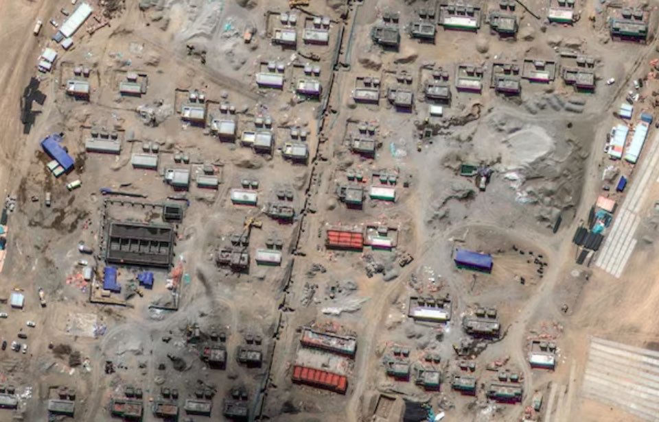
According to Y. Nithiyanandam, Professor and Head of the Geospatial Research Programme at the Takshashila Institution, the area is being developed quickly, with more than 100 buildings currently under construction. These structures appear to include residential and administrative facilities, along with open spaces that could potentially be used for parks or recreational areas.
Notably, a rectangular 150-meter-long strip in the southeast corner of the site is speculated to be designated for helicopter operations, enhancing the settlement’s strategic potential. The layout of the construction is staggered, which experts suggest could be a tactical design aimed at minimizing vulnerability to long-range attacks.
If the settlement is utilized for military purposes, it could function as an “ad-hoc forward base,” allowing Chinese forces quicker response times in case of border escalations. This development adds complexity to the already tense India-China relationship, as both countries engage in discussions to reduce military friction without a permanent resolution in sight.
Some experts, however, propose an alternative explanation for the construction. Nature Desai, an observer of the Indo-Tibetan frontier, suggests that the settlement may be intended to accommodate Tibetan nomads. He identifies the location as Chanzun Nuru, a historic nomadic site referenced in the works of Swedish geographer Sven Hedin.
If accurate, this would mark the first such settlement for Tibetan nomads in the Pangong Tso area. China has been actively resettling nomadic populations in Tibet over the years as part of its broader strategy to establish permanent communities along the border.
Despite the rapid progress, the settlement faces challenges due to its high-altitude location. While its proximity to Pangong Tso Lake may resolve water supply concerns, energy needs are likely to be met through renewable sources like solar power. Harsh winter conditions could also impact construction timelines.
Experts believe that residential structures are nearing completion, with significant advancements made over the past six months. As diplomatic efforts continue to ease tensions between India and China, the development of this settlement highlights China’s ongoing commitment to bolstering its border infrastructure, raising concerns about potential future clashes and the overall dynamics of India-China relations.
The emergence of this new construction comes at a critical juncture in India-China relations. With over 100 buildings rapidly taking shape in a strategically significant area, the settlement reflects China’s intensified focus on enhancing its border capabilities, whether for military or civilian purposes. This ongoing development underscores the challenges ahead in achieving long-term peace and stability along their contested border.

